June, 2020

Dear New Elm Lot Owners;

Hoping this note finds everyone well. Unusual times with Covid-19 and travel restrictions affecting us all.

It’s time to pass the hat around again for the road work.

Our historical contribution of $400. per lot per year over the past 12 years has built about 1.9 km of shale-base with gravel-top road together with culverts, ditches, and repairs. A remaining 2.9 km of road has not yet been rebuilt. Our biannual contribution of $800. per lot does more work at one time to decrease some of the costs and 2020 is such a bi-annual contribution and work year.

Our voluntary arrangement has worked well. Some have already asked how to contribute for this year. Previously some folks contributed more than the suggested amount, some contributed in-kind with equipment, labour and materials, and some have contributed annually instead of the double-up. Some folks chose not to contribute the requested amount in past years. We keep all un-spent contributions in the bank ($729.93 today) which neither earns interest nor incurs fees. There are 12 of us owning 14 lots between us. We are all in this together and voluntarily.

Bank account is the same as last time (2018):

Scotiabank: LAHAVE STREET, PO BOX 400 BRIDGEWATER NOVA SCOTIA B4V 2X6

Your account number: 71613 04928 25

Account holder: Robert Allan and Ian Goldsmith (ITF New Elm Estates Lot Owners Road).

We had more traffic and more winter use this year and some sections were plowed. The beavers flooded at the outer pond and we will need to deal with that. The gap around the hill has much improved drainage and is a bit smoother with two new culverts (thanks Ian) but it still needs more work and materials. The most recent (2018) gravel top layer is thin in spots.

Ian Goldsmith (Lot 2) will be doing some pot-hole filling with gravel using his machines and a couple loads of material the week of June 22nd. That will help a lot in the short term and should satisfy the local building trades contractors need for good-enough road to access job sites on our lots.

We are going to wrestle with the beaver for a while clearing culvert to get the water level down in the next couple of weeks. We may need to install a larger culvert and excluder. Ian can do that and would need to coordinate a day of outage for the work.

We worked up some estimates for our current shale-under-gravel method and two gravel-only approaches summarized in the attached future cost estimates. We are thinking about where to use gravel-only road possibly the inner stretch of New Elm Estates from Long Cove Trail to Mint Brook and Long Cove Trail itself. Please tell us your thoughts on that approach.

Urgent needs in priority order for this year are ($15,200): Beaver pond culvert ($1,0000.); gap-section at hill ($11,000 shale/gravel road), gravel cover (1”) on the 2018 section ($2,000.). A contribution budget from every lot is $11,200 which is less than the urgent needs. The work plan must fit the budget. Alternatives include shorten the gap-section, increase contributions and / or half-thickness coarse-gravel construction. Please tell us your suggestions about this also; we’re in it together.

Bob Allan and Ian Goldsmith


This stuff previously appeared in the 2016 status update.

We have identified three packages of work that seem most urgent for 2016:

  1. Cover the previously repaired area with additional gravel at about 170 feet per load (estimating somewhere around 2" deep)
  2. Complete the hill repair and replace a wooden culvert on the outbound side of the hill [ditching done 2016-08-22]
  3. Continue the inner rebuilt section out through a wet-spot to the pit.

We have completed (a) as of about Thursday the 18th of August.  It looks good.  I'll post a video link here shortly so the folks from away can see the new stuff.  Materials and cost was: 13 loads $4221. taxes in.

We have estimated the cost of (b) at somewhere around $4,800.  Caution that Bob made those estimates, not Darell, so we'll soon see if the guess is near.  The ditching part was completed 2016-08-22 and it looks like we don't need a culvert.

We have estimated the cost of (c) at about $3,000. Again, caution - non-experts are estimating.

With the funds in the bank (13,987.50), this is all we can afford this year.  It will be really close to complete these if our estimates are correct.   Watch this space for more updates and links to video and photo as the work progresses.

We took a walk out the road and jotted a few notes as the basis of our current and future plans.  All comments are welcome.  We are acting within our avaialble funds (above) for the 2016 year and taking votes and offers to "adopt a patch" beyond that.

We began the walk from the inner end of the road.  The new surface of class A is really nice.  It’s a bit soft for a bike (motorcycle) but is packed down really hard in the wheel tracks where the gravel truck ran over it.
We come to the new 30” culvert and consider the beaver.  A beaver excluder in the trapezoidal style could be built there.  Upstream looks like 15 or 16 feet on a side and 7 poles.  Bending the 7 foot wide sides under by one foot would provide adequate height to be above the road surface and hence always above the water level.  The maximum width of 16 feet could be two 7’ strips joined to the turned under edges.  Plan to use 5 strips at 16 feet length off a 7’ wide roll.  The downstream side is limited by the terrain to a rectangle, perhaps 12’ long and about 7 feet wide at the lower end.  Building that from 3 strips 7’ wide x 12’ long and 6 poles.  See the beaver excluder reference: http://www.beaversolutions.com/beaver-deceiver-products/beaver-proof-culvert-keystone-beaver-fence/
 
Wet spot 1:  Where the gravel replaces the big-o; formerly known as the French Drain or the Load of Class C gravel (in the mapping).  We think that will need some work sometime but for now it is really only an issue in the early spring and the high clearance trucks can pass through the 6” of water that accumulates during the melt.  We don't see running water across this stretch of road.  It may be that raising the road would be sufficient but using something other than shale due to the standing water.
 
Wet spot 2: between the end of the inner new section and the pit; the part where a load of shale has been dissolved into the road.
Span is about 60 paces (120 feet) from the end of the new-road out to the brow of a knoll where the real-bad spot begins, then there is 100 paces (300 feet) of pot-holed and dissolved shale and then another 15 paces (45 feet) that is not so bad but really should be done if we can.
The 300 foot middle section needs some excavator ditching, light work perhaps.  We need to build up the height a bit for drainage and make the base solid with shale.  Class A gravel over the top obviously.
This is currently our third item in 2016 plans.  (done, 2016)
 
Wet spot 3:  This is the puddles at the low point of the road around the hill.  There is drainage available on both sides of the road and the up-hill side doesn’t have a large catchment of run-off since it is the forested hill made of sand and gravel so less runs off there than other places.
 
The road around the pit hill is all about the same, no part really worse than others.  The surface has emerging rocks, some of which can be removed by hand.  The surface is solid but quite deeply rutted in places which affects ground clearance and ploughing more than driving in trucks. (rock pulling with the excavator and some ditching, 2016)
 
Top of hill:  Between the 2014 hill section repair and over the brow of the hill.  We also include the wet stretch after the hill before the spring-pit in this section.  That wet spot has a wooden culvert that is failing (road sinking).  There is some ditching needed and some shale and raising the road in places.  Darell recommended a 12” culvert replacement for that wooden one.  [update 2016-08-22, after ditching looks like the culvert replacement won't be necessary at this time.]  This is really two adjacent stretches of road, but we describe it together since they are both in our plans for 2016.
The span is about 195 (585’) paces with 100 paces (300’) up-over the hill and about 95 paces (285’) across the wet spot. (done, 2016)
 
Wet spot 4:  The gully at the bottom of the short hill just after the pit.  The water runs down the hill from both sides, but mostly from the outbound side.  The puddles poole in the bottom leading to splashing in the rain and splash-deepening.  We have picked drain channels from the side.  Cutting the side off to improve drainage may help but it risks cutting into the hard surface.
The hill on the outbound side of the gully is fairly good and solid, the material is more crushed rock like and seems to be holding up to the running water.  A repair along this stretch would need some ditching and some shale for both base strength after removing rocks and for height to stay dry. (done, 2016)
 
Patch 1:  This is our first example of a piece of road that could be patched rather than wait for the rebuild work to catch up to the stretch.  It has fairly good road on either end but has potholes and rough spots and is a bit low leading to water accumulation.  It doesn’t need ditching, just shale (1 or 2 loads), and perhaps a 1/2 load Class A to over.  This is closely adjacent to Wet Spot 4 and it may make sense to do them together. (filled with shale, 2016)
 
Patch 2:  This is a stretch of about 200’ that needs some ditching, mostly grading the edges off for drainage plus shale and gravel. (filled the holes with shale, 2016)
 
The road is pretty good then for a while.
There’s a wet spot in a low spot in the middle of the road but it is firm and smooth and really only makes the truck muddy.  There’s some good firewood on the side of the road there.  (rock pulling with the excavator and some ditching, 2016)
 
Flying Bear Pond Patch:  There is a stretch of wet and rough road across the dam of about 50 or 60 paces (180’).  This stretch just needs shale and gravel and the dozer to raise it and smooth it out.  There is a ridge on the downstream side of the road surface that is holding water which is a  candidate for a grading run with the dozer as long as we are following up with some surface material afterward. (added some shale and improved drainage, 2016)
 
Snow Gully 2:  The rough road with a low spot that holds snow and ice in the winter.  About 240’ long.  The road is rough with rocks and potholes.  Looks like dozer and grading with shale, think about 6” deep, and then cover with class A gravel. (filled holes with shale, 2016)
 
Then there is a stretch of road that’s just a bit rough but solid and no big potholes.  (rock pulling with the excavator and some ditching, 2016)
 
Patch 4:  a 250’ stretch with pot holes leading to a brow of a small hill.  (rock pulling with the excavator and some ditching, 2016)
 
Patch 5 (aka Snow Gully 1): is connected to Patch 4 and is another 200’ of pot holes and roughness with one low spot that collects snow and ice in the winter.  This is the Snow Gully where Paul and Bob were getting stuck during the spring of the big-snow (2015).  Fix seems like shale and class A with the dozer.  (filled with a load of shale, 2016)


With many hands to make light the work, we had some fun building the beaver excluder on the weekend of 24/25 September, 2016.  Thanks to Paul, Natalie, Dave, Marian and Bob.

You can see a short descriptive video here; Talking tour of the beaver excluder

The up-stream side looks like this:
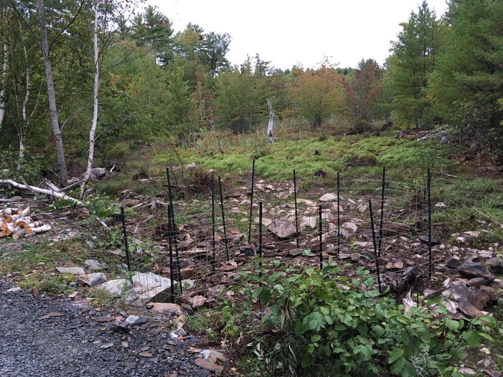
Beaver Excluder Upstream


The downstream side looks like this:

Beaver Excluder downstream side

A bill of materials:

  • Reinforcing mesh (like for concrete floors) 6 x 6 mesh, 10 awg, 4 x 8 ft. 22 pieces at $8.49 ea
  • T-rail fence posts, 8 feet long, 21 pieces at $8.99
  • Wire (electric fence, galvanized, 17 awg) a lot less than the 1320 ft rool at $27,99
  • Hog Rings, Malco HR2 Hog Rings, 1000-Pack (we used more than half of those) at $33.

And a receipt"
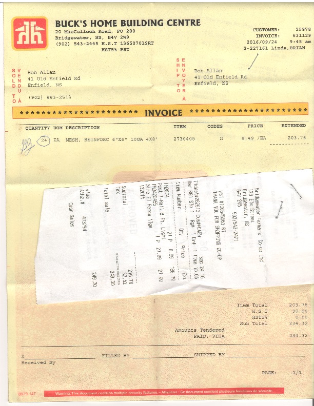
Beaver Excluder Receipts